I think its pretty clear the effect COVID had on this blog - but looking back at it - so much work, im going to have to revive it in 2022. Twitter is great but you cant discuss things in much detail. So here is a token post so 2021 doesnt go totally underrepresented and lets hope 2022 I can get back into it. I mean 5*S doesnt even get mentioned!
Tuesday, 14 December 2021

Monday, 17 February 2020
Celtic Voyager Trip
The second stage of GY643 ended this weekend - what a great module.... A very early start Saturday morning saw us meet at Horgan's Quay in Cork with the two survey vessels tied up at the pier - we were on the Celtic Voyager for the weekend (below). The bigger Celtic Explorer was moored alongside.


Day two was a much sunnier affair - although had been forecast to be worse. We got to go on deck more often, see the sights and had a good look at naval vessels tied in Haulbowline. Fascinating experience - quite a few of the students looking at that as an option for their work placement now.


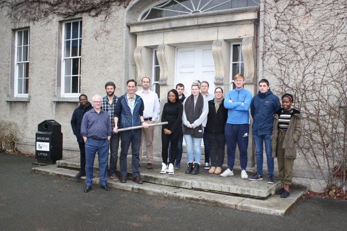
The range of things the ten students were exposed to in the two days (not including Storm Denis) was incredible - and in detail too, with a chance to apply it themselves in practice. The whole experience of being on a ship like that from eating in the mess, to working in the dry lab and wet lab was really an experience students could not normally get, plus with 4 science staff and all the crew giving demos of many of the ports and practices they were really lucky to get to learn in such small groups. We found a nice sheltered spot down past Ringaskiddy and parallel with Cobh promenade and worked there in the wind and rain for most of Saturday taking seabed samples, carrying out multi-beam and singhle beam surveys and the only thing the weather stopped us from doing was seeing the ROV in action. Freshly cooked goulash for lunch on Day 1 and shepherds pie Day 2 - can't ask for better than that.

Day two was a much sunnier affair - although had been forecast to be worse. We got to go on deck more often, see the sights and had a good look at naval vessels tied in Haulbowline. Fascinating experience - quite a few of the students looking at that as an option for their work placement now.

Monday, 27 January 2020
Marine Remote Sensing - Module Co-Developed with Industry
Last week brought the theory element of GY643 to a close - the first postgraduate marine remote sensing module in Ireland. This module was notable for another reason too - it was co-developed with industry. Early in 2018 we began working with Geological Survey of Ireland and the Marine Institute (the partners on INFOMAR - the national seabed mapping programme) on developing the structure, content and model of assessment etc for a 10 credit postgraduate module. Judging by early indications and the student feedback the theory and lab based practivcal element was very well received. The next stage - the boat time in February - will round off the module nicely. Lots of useful feedback and thanks to all the speakers and students for helping out this year.
Wednesday, 15 January 2020
5*S is Hiring
5*S has its own Twitter page now for those interested (yes, i made the logo...)

We're also hiring. Maynooth Geography are hiring for a Postdoc/RA and also a Software Developer.
The PD/RA will develop new Copernicus related content for the Esri ArcGIS In Schools programme and provide training to interested professionals/teachers-in-training in return for enrolling as a GeoMentor. Job spec here
The Software Developer will develop new Augmented Reality teaching tools (i'm really excited about the possibilities with this one) to introduce students to Copernicus data via mobile apps and help improve their spatial skillsets by adding elements of interaction. Job spec here
Closing dates for applications is 31st Jan approx - and we're hoping for an almost immediate start.
Must have drivers license and car...
Tuesday, 31 December 2019
2019 - A year in review
2019 was another good year.
Work on the OSi project coming to a successful conclusion, 3 journal papers published (one with Remote Sensing of Environment), 2 surveyors journal articles published, 2 EO sessions at EUGEO, a SFI Discover award, through to last stages of SFI Frontiers, managed to get an ERC proposal submitted, co-developing the new INFOMAR module, collaborated on national space strategy - and sponsorship of a eBee drone from KOREC!
Think that's it - time to enjoy the holiday.
Work on the OSi project coming to a successful conclusion, 3 journal papers published (one with Remote Sensing of Environment), 2 surveyors journal articles published, 2 EO sessions at EUGEO, a SFI Discover award, through to last stages of SFI Frontiers, managed to get an ERC proposal submitted, co-developing the new INFOMAR module, collaborated on national space strategy - and sponsorship of a eBee drone from KOREC!
Think that's it - time to enjoy the holiday.
Friday, 20 December 2019
SFI Discover - Space, Surveyors and Students: STEM and Sustainable Development Goals (5*S)
Very pleased to hear that our SFI Discover proposal was successful - Space, Surveyors and Students: STEM and Sustainable Development Goals (5*S)

5*S builds on two existing national school-based programmes to target a national audience. A collaboration between Esri Ireland’s award-winning, ‘ArcGIS for Schools’ programme and the Society of Chartered Surveyors ‘Day in the Life’ recruitment programme offers the opportunity to combine a national network of volunteers with an existing data and training infrastructure in Irish primary and post-primary schools. Added to that 5*S was awarded funding for a software developer to work on AR and bring Copernicus into the schools.
Project partners are Maynooth Geog, Maynooth Dept Education, TU Dublin, Esri Ireland, Society of Chartered Surveyors Ireland and Ordnance Survey Ireland - collaborating with ESERO/SFI.
We'll have more info in 2020 and announce it properly but here's the Silicon Republic article
Saturday, 30 November 2019
New Paper: Spatially Optimised
Glimpse getting another outing with a recent LiDAR/point cloud paper in the Journal of Spatial Science with a few NCG alumni. Dr. Pankaj Kumar (now in Uni of South Australia) lead author.

Spatially optimised retrieval of 3D point cloud data from a geospatial
database for road median extraction

Thursday, 31 October 2019
"The Drone" - A Post for Halloween....
Its not often I have a geo-related 'Halloween' blogpost - but I came across this movie on Sky movies recently and could not believe my eyes...someone seems to have cast a standard DJI Drone as 'the murderer' in a recent movie. It has everything to shock and horrify a licensed drone pilot - unsafe flying practices, dangerous maneuvers in shared airspace, flying indoors, GDPR violations - it even looks like it weaponises poor battery charging procedures. The thing that will push me over the edge is if they don't back up their data at the end...horrific.

Wednesday, 30 October 2019
ICESAT 2 and Bathymetry
IceSAT 2 was in the news recently - people have been using it to map the seabed/water depths. This is good news - the availability of recently captured calibration datasets (no matter how sparse) is a major impediment to roll-out of satellite derived bathymetry, as the seabed changes so much over time in places and the calibration data should ideally be captured close to the time the image was captured at. Laser wavelength is in the green portion of the spectrum - so good for penetrating water - wonder where they get the surface from? Weaker returns maybe? Tide gauge nearby?
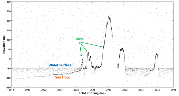
I had a look to see what sort of coverage we had for coastal regions in Ireland and was directed to the excellent openaltimetry website. Looks like we have one scanline running through Tralee bay, another through Dublin bay - both sites we have published papers for but used older calibration data.

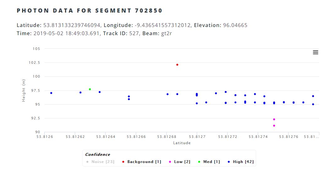
If you look closely in the image above - you can see there are points to the left and right of the green scanline - I dont know enough about the system yet to know is the profile spacing actually less (p.s. less is better) than that image suggests, or is that something to do with image footprint (unlikely as it is only 17m according to the website). You can use openaltimetry.org to have a quick look at profiles anywhere in Ireland - wonder would it have picked up the change over the National Ploughing Championships...
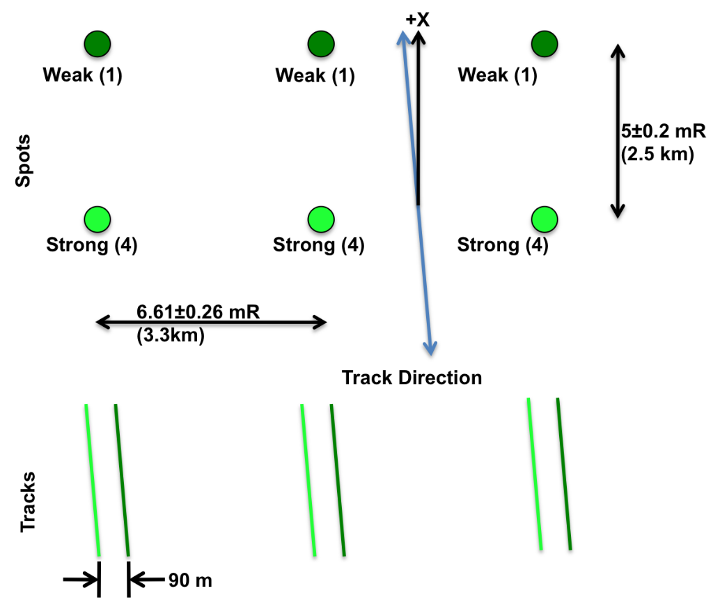
Update: Here's my answer - 6 beams organised in 3 pairs, with a weak/strong combination. Probably also answers the water surface question too..
Tuesday, 22 October 2019
EARSC Market Report
The annual EARSC report is out, summarizing the European Space Industry and Market in 2019. Always an interesting read - I was please to see Ireland moving up the '"Number of Companies" ranking, ahead of number of larger countries, so a great sign that things are moving in the right direction. We will see how the recent launch of the national space strategy effects this.

It certainly should effect it positively, as only yesterday Minister Halligan was in the news announcing some success stories in Irish industry and also a new €500,000 fund to help private industry collaborate with public bodies on space based projects. Very interesting to see ESA will also be partnered with Maynooth University in organizing this fund, so more good news there.

I can certainly see plenty of opportunities for collaborations and know multiple public bodies looking for expertise, the problem is finding the right partners in private industry.
Wednesday, 9 October 2019
ERC - again....
Academia is a funny old fish - three years ago I was tapping away at the weekend on an ERC project proposal, only to be surprised by an early arrival. Three years later at that 'early arrivals' 3rd birthday party I'm busy revising that proposal for resubmission. Lots changed in those three years, mostly my knowledge of Thomas the Tank Engine and Dinosaurs.
Update: ok - submitted. Now to deal with the massive backlog that has accumulated!
Update: ok - submitted. Now to deal with the massive backlog that has accumulated!
Thursday, 26 September 2019
Our new eBee RTK - a donation from KOREC
We had Helen Gilmartin from Korec onsite earlier in the week. Immediately after greeting the new cohort for the MSc in GIS/Remote Sensing we went outside to use the lovely autumn colours (and the new MSc cohort) as a backdrop for the photo of a drone handover. Korec very generously donated a fixed wing RTK drone - the eBEee RTK to the department and this hardware going to be really important for lectures and research in the coming years.
 |
| The students... |
 |
| And the lovely colours... |
Monday, 23 September 2019
Sentinel in the news again
There are very few days go by that satellite data or remote sensing is not mentioned in the news. You might need to look hard at the article as its often just a brief mention - supporting some other big announcement - but is usually the key enabling technology. Glaciers retreating, forest fires in the amazon, some unfortunate animal under threat - but inevitably you will see 'satellite data' mentioned, either one of the big free datasets like Copernicus or Landsat, or some of the high resolution vendors like Digitalglobe.
The latest in the Irish media is a reference to Ireland's need of a good land cover/land use map, as we have been making do with CORINE to date with according issues relating to accuracy, resolution, class type,etc. The good news is that there is a collaboration between the EPA, Teagasc, OSi and others underway to develop new landuse datasets to fill this hole - using OSi high resolution multiband aerial images and combining these with the high temporalresolution of the Sentinel satellites. I've been involved on some land cover mapping with OSi on the change detection project, and when presenting this work at IEOS2019 in Teagasc before christmas the previous speakers were the EPA/Osi and the new datasets look great. Watch this space as land use maps will feed into pretty much every monitoring or assessment task you can imagine. Accurate, regularly updated land use maps (that's where the satellites come in) can predict and prevent pollution, flooding, effects caused by climate change, urban sprawl, poor agricultural practices, you name it.
And keep an eye out for space data in the news - it is there almost every day.
Tuesday, 17 September 2019
Paper Published: Remote Sensing of Environment
The GSI shortcall in 2015 gave us the opportunity to look at ways of applying bathymetric derivation algorithms to high resolution imagery. We looked at RapidEye (5m), Pleiades (2m), light aircraft and drones (sub-decimetre). The project focussed primarily on the airborne and drones (report available here) but gave us valuable insights on what we needed to take the algorithms and begin to adapt them for satellite data provided through ESA TPM license. We were then able to advance the work begun with the Dublin bay bathymetry paper and look at applying spatial and non-spatial models to improve accuracy of satellite derived bathymetry (spoiler - helps as depth increases). This was a multi partner project - I've been working on it over the 4 years and includes NCG, Rothamstead Research,Geological Survey and industry. Great to see it finally published in such a good journal.
Available to download via open access here

Monday, 26 August 2019
Rohingya Crisis and EO
I see the Rohingya are back in the news again, after almost all of them turned down an offer of repatriation - satellite imagery is helping monitor the expansion of refugee camps in Bangladesh and other countries where they ended up, plus the razing of their old villages. Most interesting/horrifying was to see that all the work that has gone ahead on Bashan Char (not Thengar Char as originally reported - some confusion on what soggy mud island we were looking at confused everyone). Ive posted about this before on twitter, but look at the gif below from thenewhumanitatiarn.org to see it yourself.

And if you want to see just how precarious living on this island is - look at this map and this map produced by ESA showing how often parts of the island are under water. And that is without rising sea levels..


Tuesday, 6 August 2019
Fake News Makes it Way to EO
The director of the Brazilian National Space Research Institute (INPE) has been sacked for presenting results from satellite imagery showing severe deforestation under the current Government, and then arguing their accuracy following official criticism. The data was just added to a dashboard on a government website - no big splash was made of the news, but still it caught the government's attention. The President and ministers said it was all 'lies' and that INPE was in the pocket of a 'foreign not for profit group'. The environment minister is claiming many of those spots have been showing as deforestation for years in 'their data' - but has not released the data nor the methodology to refute the INPE claims.

Wednesday, 3 July 2019
BIM From Space - Part 2
BIM From a Distance - Part 2 is out now in the Summer edition of the Surveyors Journal - what more could you want on the hottest day of the summer so far!? Take a look now to find out how the SCSI port mapping study story ends - spoiler alert - the satellite did it.
God, i'd love an ice-pop.

God, i'd love an ice-pop.

Sunday, 23 June 2019
National Space Strategy Published
The National Space Strategy Consultation of July 2018 got some useful info and feedback - as part of the SCSI RS & EO working group we provided feedback from the mapping/built environment/property sectors - and the follow up meeting in August was an interesting experience with lots of stakeholders gathered to voice their opinions. The culmination of all this work resulted in the launch yesterday by Minister Halligan of the first National Space Strategy for Ireland 2019 - 2025. Plenty of food for thought and the section on upskilling in particular caught my eye following a recent SFI Discovery submission.

Tuesday, 18 June 2019
Drone Industry Day - Maynooth University
Thanks to Tim and the team for a very interesting day of talks on North Campus. Beginning with an update on the rapidly approaching European Drone Regs - and followed by speakers discussing things ranging from Manna (the best name ever for a drone food delivery company) to ways to stop wifi, radio or GPS piloted rogue drones - i got plenty of food for thought. One of the tools shown on the video was a giant electromagnetic gun that can fry a drones circuit-board from quite a distance.. Advances in UTM are one to watch and one of the early speakers told us that the first apartment (i can't remember if its an apartment or a block of apartments) built in London with its own drone delivery pad is opening tomorrow. The times they are a-changing...
Thursday, 13 June 2019
New Drones @ Department of Geography
Took delivery of two drones this morning.
One is a Parrott Bluegrass - a rugged, out of the box rotary drone with a forward facing oblique RGB camera and a nadir looking Parrott Sequioa. A very nice piece of kit, eliminates many of the issues I spoke about before with bespoke integration mounts for sensors on the DJI series.
 The other is a fixed wing - covers a much wider area and has RGB capability via a canon camera.
 Looking forward to testing these two out - need to renew my SOP and license and then up, up and away.....
One is a Parrott Bluegrass - a rugged, out of the box rotary drone with a forward facing oblique RGB camera and a nadir looking Parrott Sequioa. A very nice piece of kit, eliminates many of the issues I spoke about before with bespoke integration mounts for sensors on the DJI series.
Subscribe to:
Posts (Atom)
About Me

- Conor
- My name is Conor. I am a Lecturer at the Department of Geography at Maynooth University. These few lines will (hopefully) chart my progress through academia and the world of research.