My new years resolution is to use less plastic - thanks Blue Planet II - one of the big problems it has highlighted is large patches of ocean plastic, some of them as big as a large country. With projections estimating that there will be more plastic in the oceans than fish by 2050 it is important to start finding the problem areas so solutions can be developed and targeted. That is where I am not surprised to see EO playing a role. Looking for the spectral signatures for plastics, imagery from satellites such as Sentinel 3 is playing a role between ESA and industry partners in helping to do just this and creating maps measuring density of plastics in ocean regions.
Saturday 24 March 2018
Saturday 17 March 2018
GDPR and Drone Operations
I attended a very interesting CPD event at SCSI HQ earlier in the week - it covered upcoming changes to regulations for drone operations and also privacy issues. Privacy for drone surveys had always been a bit of a grey area, the IAA weren't regulating it, the Gardaí weren't - etc. The big change coming down the line will be the EU's General Data Protection Regulations (coming into effect on 28th May) and privacy will be a major consideration then with massive penalties for non-compliance (up to 10% of a companies annual turnover!). Terms such as a data processing impact assessment should put shivers down the spines of anyone considering flying in the coming months until it is clearer what effect it will have on surveyors and also the best way to plan for it.
As the Christine Woods from Matheson explained - "act now as preparation is necessary to achieve compliance".
Wednesday 14 March 2018
Clouds in Google Earth
I just looked at the new Google Earth in my browser - I don't have the desktop version installed ion the DIT PC yet. Your first view is a beautiful 'blue marble' / globe that reminds me of the old Civilisation games.
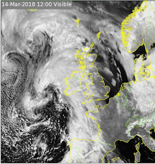
As I zoomed back out hoping to enjoy the view of the whole hemisphere with Ireland at the centre point, a pile of cloud appeared over the country and most of Western Europe. "What a pain", I thought but also admitted it was quite realistic as it is lashing down outside (the second years spent the day down the minesin Tara, a perfect day for it - warm and dry) and it occurred to me that it just might be a real time feed? So I checked it against the Met Eireann full-disk satellite feed and lo and behold it matched that shape exactly. So real time cloud maps are available by default in Google Earth - impressive.
 |
| Google Earth |
 |
| Met Eireann |
Subscribe to:
Posts (Atom)
About Me

- Conor
- My name is Conor. I am a Lecturer at the Department of Geography at Maynooth University. These few lines will (hopefully) chart my progress through academia and the world of research.

