Monday 29 February 2016

COST Action Workshop - Feb 2016

Just back from a very interesting three day workshop in Dubrovnik. I missed last years COST action MC meet as I had lectures so I had to make this one, despite it being 3 flights each way! I also had to stay a day late and travel a day early as off-season Dubrovnik is not an easy place to get to. Some good talks though and we got a great overview of the recently approved Copernicus Earth Explorer mission, FLEX from the person who lead the proposal - Jose Moreno. Good to see some familiar faces from Milan and Poland.

Thursday 18 February 2016

Trade Journals V Peer Reviewed Articles

I have been asked to write articles recently for two non-peer reviewed publications, Hydro International and the Surveyors Journal. One of the articles is on EO and flood mapping and the other is on satellite bathymetry. It is a very different writing style to what I have been doing over the last 7 years with prepping conference papers, journal papers and a thesis.. Instead of max detail, leave no stone unturned, the opposite is the case and things have to be made more reader-friendly for the wider audience.


I sent off my drafts recently, will be interesting to see whether they take a hatchet to it or how much gets through.

Thursday 11 February 2016

Sentinel 3a getting ready!

Here is the ESA blog charting the last days to the launch (16th Feb). You should also be able to watch the launch live. Details on the Satellite here. I really liked how they choose the rocket logos - apparently it is a tradition to associate each Rocket launch with a constellation made of a number of ‘bright’ stars equal to the number of the launch. This is 25 - so they chose the Libra constellation.


Friday 5 February 2016

Hyperion

There are some really great, free data resources out there. A few months back I noticed when searching for free Hyperspectral imagery that there were a number of strips available for Munster and into Leinster.


After a bit more searching I found that the USGS and NASA were allowing members of the public to request Hyperion taskings for free. Not just free data as they are collecting it anyway - but specify an area you are interested in and they will task the satellite to capture data of that area. Years of Landsat data made available for free, GPS for free, Hyperion tasking for free - well done America. 

"The USGS, in partnership with NASA, is providing a mechanism for the general public to specify location and timeframe for future acquisitions of data from the EO-1 satellite. There will be no charge for these tasking requests and they will be satisfied on a best effort basis as capacity is potentially available from EO-1."

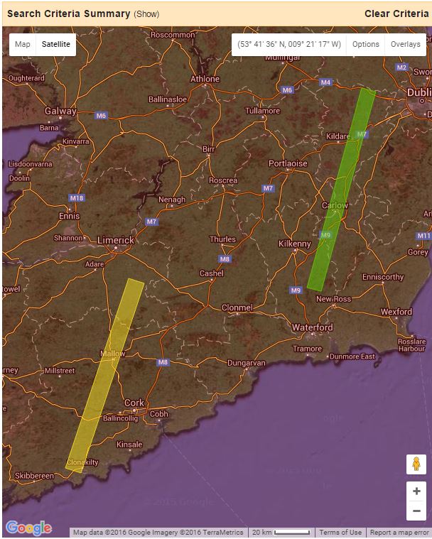
This dataset came up again in conversation recently so I decided to request some of my own for a project. i have requested Dublin bay, Kinvarra bay and Mulroy bay. I do not know if the more requests you have the less chance of getting it but I think I might put one in for Tralee bay too.

Tuesday 2 February 2016

Ireland and Satellite Derived Bathymetry

The SFI funded industry fellowship officially ended on Friday last. This was a two year (but half time) project in conjunction with TechWorks Marine Ltd (Dun Laoghaire) aiming to develop a satellite bathymetry methodology through a combination of optical processing and spatial regression models. Some promising results, potential commercial outputs and definitely represents a step forward. We also had a paper published during the year on the results from a previous test-case. The outputs from the SFI project have yet to be finalised and published so the official end is definitely not an end.

A satellite derived bathymetric map for Mulroy bay (our first test case) is displayed below.


About Me

My photo
My name is Conor. I am a Lecturer at the Department of Geography at Maynooth University. These few lines will (hopefully) chart my progress through academia and the world of research.