Tuesday, 13 January 2015

Bramor from c-Astral

I spent the end of last week going through the ground school and simulator training for the Bramor from c-Astral. The Asctec Falcon 8 is a great piece of kit and lots of our earlier projects went really well, but the Bramor is really in a different league. The Falcon 8 is an Octocopter, small, very sturdy and manouverable, useful for surveying small areas or inspecting buildings and other vertical structures. It can be carried in one hand, launched from a roof, and if you're brave enough, caught in your hand on return as the manufacturers demonstrate.

The Bramor on the other hand, looks like a stealth-bomber


Needs a catapult to launch


And a parachute to land.


High speeds, long range, high altitude capability.

All currently forbidden by regulations.

Monday, 5 January 2015

Shiny New Year

Happy New Year to everyone.

First post of a shiny new year is nothing to do with remote sensing or Geomatics, but rather an interesting research article I came across on Science Direct about the reason behind our love for shiny things. Apparently our love for shiny/glossy things goes back to our need for water! Paper is here. People generally prefer things printed on glossy paper, but their preference for shiny/glossy material increased significantly after the survey participants had been given 8 salty crackers by the Belgian scientists.
A busy 2015 ahead, the next few months particularly so. A new Remote Sensing module to give at the end of the month, multiple SFI reports due, a SFI bathymetry project deliverable, UAS groundschool and flightschool in Cork, persuade the SCS to let me transfer the IIS commission on Remote Sensing over, software development with NorbSoftDev (we hope to have the alpha version ready by the end of February, then only have two months to get to Beta and a RC - June release deadline).

Looking at that list after the last week or so of slothful gluttony it makes me want to go home and eat turkey and cry into my tin of Roses.

Friday, 19 December 2014

The Bridge

Page 23 here - a short article published in the Maynooth Alumni magazine on the SFi project. The Bridge goes out to alot of people (do they do a print version? I'm not sure), and always good to get a mention anywhere.


Two TV appearances this year, a photo with a minister, three newspapers/magazines and a radio interview on Tuesday about my work with Santa - this showbiz lifestyle of mine!

Shame I'm just a poor Post-Doc.

Happy Christmas and New Year to everyone!

See you in 2015.


Monday, 15 December 2014

Santa's Official Scientist

Remote sensing has lots of uses - forestry, coastal, agriculture, engineering, marine - but lets face it, it's really all about Christmas. I had a short article published in the, 'Science of Christmas' supplement in the Irish Independent last week. The link is here if you are interested in reading how Santa uses remote sensing to find people's houses.


Monday, 1 December 2014

IIS SCS merger

I posted a while back about a proposed IIS/SCSI merger. At the Extraordinary General Meeting in the Davenport hotel, Friday 29th November 2014 - 70 IIS members (roughly 25%) voted on the merger. This was easily the best turnout for an AGM or EGM that I have seen since the days when the AGM used to follow on in the evening from Survey Ireland. Great to see too, it was an important vote - easily the most important vote.


The Vote
The result was surprising. Off the top of my head I think the final tally was: 68 for the merger, 1 against and 1 abstention. That is about as unanimous as you could ever hope for. One of the worries I had was that it would be a 51/49 split but thankfully that didn't happen. The night was also a celebration of the IIS's 25th anniversary to it served a dual-function.

IIS Commission
What does that mean for the IIS commission on Remote Sensing? I honestly don't know but I hope to propose it to the board of the Geomatics division of the SCSI in the new year. Now that we have the clarity that was missing due to the question mark over the future of the IIS we can start to get something done. 

So what does this mean for me?
Much higher membership costs for one thing. Almost double what I currently pay if I opt for Fellow of the SCSI and Fellow of the RICS. And that's IF I get the academic discount. I need to look into that. If I don't I'm looking at nearly €850. Do I need to be a chartered surveyor in research and lecturing? That remains to be seen, I'll probably pay it for the first year at least.

Thursday, 20 November 2014

Sentinel Costa Concordia

I posted a few months back about the launch of Sentinel 1a, the first of ESA's new Sentinel constellation to go into orbit. Well some data is starting to come back. Here's a not-very-scientific-but-still-interesting example...

After the Costa Concordia incident in 2012, an image was doing the rounds in the newspapers/websites of the wreck from space (possibly from EROS-A?)


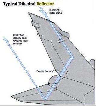
That was taken by an optical satellite and unsurprisingly it looks like any digital photograph. Sentinel 1a is different. It is a RADAR satellite so you don't get a 'photo' but rather an image representing the amount of energy that has hit the target and returned to the receiver. This is dependent on the roughness of the object. High scattering should lead to a strong return and in most cases is due to the micro-relief of an object. Bright areas in these images implies high amounts of scattering whereas dark areas mean low scattering. Objects with corners (if you look closely, the side of the Costa is full of them) also give very high returns because they focus most of the RADAR pulse back at the receiver. That's why stealth vessels and planes have such odd shapes and outlines. Aside from being made of materials that absorb RADAR pulses to a certain extent they are also designed to have a low radar profile and channel as little of the radar pulse back to the receiver.


The example i want to show you is of the Costa Concordia, post-refloating, being towed. The image (below) is from Sentinel 1a. You can see the large return from the larger vessel and the smaller returns from the smaller tugs and police tenders.


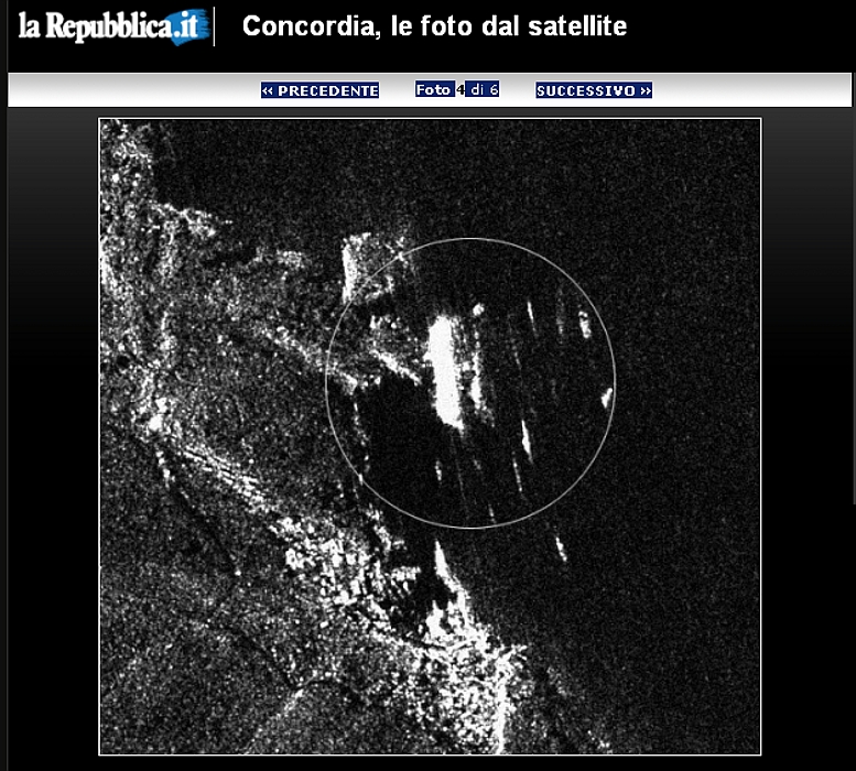
I also came across another image online (below). It looks like RADAR but the source is unknown. It seems to show the Costa Concordia in a similar position to that in the optical image I first posted. The vessel is on it's side, surrounded by security vessels / rescue craft.


Looking forward to lots more from the Sentinels.

Tuesday, 11 November 2014

Teagasc & NCG PhD

This is old news now but I forgot to post after it happened. The interviews were late September (or was it early October?) and we filled the Walsh Fellowship PhD position.


The candidate has already started. The topic is "Precision agriculture tools and their application to land drainage issues in Ireland" and the candidate will be using satellite imagery and UAV sensors for the study. More info here.

They will be based in Teagasc some of the time and in the NCG some of the time.

Good luck with the research.

About Me

My photo
My name is Conor. I am a Lecturer at the Department of Geography at Maynooth University. These few lines will (hopefully) chart my progress through academia and the world of research.