Some excellent WW1 and WW2 propaganda maps
here compiled by the National Geographic - you really need a monitor to appreciate them - it won't load properly on a phone. I could look at these for hours, there is just so much going on. Would be nice prints for a wall.
What is in the hands of "Ireland" in this WW1 one? A bottle for sure - but what are the tweezers?
Portugal looks quite content in this one - only country in Europe that is.
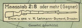
And is this rifle supposed to be a scale bar?


Maps with informative content are always useful & powerful. And these propaganda maps would have also been succeeded in changing the mindset of their targeted audience. It would be interesting to see that how these maps would look like in current political & economic scenarios (e.g. in Brexit case) !!!
ReplyDeleteLooks like Ireland is holding scissor in its struggle for the independence from Britain.
It is a scissors - well spotted. I had not noticed the chain linking Ireland and Britain.
DeleteHappy New Year, Conor. Grabbing Tentacles are a common feature of several of those maps. Very modern looking stylistically in some instances. Interesting re-positioning of Japan too. That map seems to have been produced in a few variants as well, including one using an animal motif, depicting the UK as a crocodile or alligator and Ireland as a toad or frog. The make interesting wallpapers for your laptop or PC! You might be interested in this website documenting sites in Ireland which were marked to alert belligerent forces that they were approaching or over neutral territory http://eiremarkings.org/
ReplyDelete