Monday 23 April 2018

MIssing Type XXI U-Boat found - MBES Scan

Aside from Maps and Geography I'm also a big History fan - especially military history - I soak the stuff up, everything from classical Greek up to WW2, but the Battle of the Atlantic is  definitely one of my favourites - Storms, U-Boats, Aircraft, Convoys, etc. Some of my earlier posts on shipwrecks have mentioned these wrecks scattered around the Irish coastline.

I was interested to read in the news of late that the wreck one of the very few Type XXI U-Boats  to see active service was recently found using multibeam SONAR. These were really revolutionary vessels - arguably the first real 'submarine' with theoretically unlimited underwater performance - everything up until then had just been a 'submersible'. The Allies plundered this tech mercilessly in the post war - early cold war years and fed into design of the diesel SSKs and early nuclear SSBNs and SSNs.

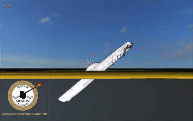
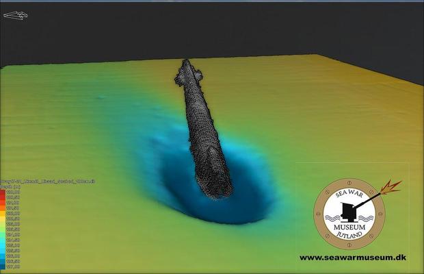
It is quite a dramatic wreck too, telling a lot about the last moments of the ship. U-3523 is buried from the bow up to the midships in the mud near the Skaggerak (Denmark) at almost a 45degree angle, it must have hit the seabed with some force. Uncontrolled flooding, bowplanes stuck - who knows what happened following the aerial attack to have made U-3523 plow into the seabed at that angle, 120m below the surface but this is one of the boats that had long been rumoured to have slipped off to South America with Nazi gold and/or war criminals and that story can also be laid to rest now.


Tuesday 10 April 2018

Dun Laoghaire Pier - Network Surveys

Monday was a beautiful day out in Dun Laoghaire for the start of the network survey with the 2nd year Geos. Windy but sunny - the clouds started to roll in around 3pm, reminded me of my lunchtime walks when I was working with TWM before the office moved. Had a quick look around the library too - impressive.


Stage one as always is the recce - but when the students returned it turned out that large portions of the upper east pier was closed off due to storm damage either from Ophelia or Emma. I don't know if these slabs had been moved by waves crashing in and up from under the pier or they are the replacements (they don't look damaged) or else they had to remove them to access other damage but still these are big pieces of rock...


This meant all of those stations had to be repositioned for the network measurements and the rest of the day was spent doing that, only allowing a short amount of time in the PM for measurements from stations at the ends of either pier. This also meant reduced visibility as the students were now trying to see across the harbour from lower down. Lots of radio contact required to ensure inter-visibility,


Level survey and topo to follow later in the week but I am off to Grangegorman to help with the first year field trip there, looking forward to seeing it.

About Me

My photo
My name is Conor. I am a Lecturer at the Department of Geography at Maynooth University. These few lines will (hopefully) chart my progress through academia and the world of research.