There is a great example doing the rounds on social media at present of the power of satellite imagery for mapping changes in the landscape. Google Earth Timelapse combines all of the available archive Landsat digital imagery (from approximately 1980 on so I'm guessing L4 is the earliest) to present almost 40 years of continuous imagery for looking at changes in the landscape. The really powerful thing is that this is available in a web broswer for anywhere in the world. Just zoom, pan and move the slider. No processing or RS knowledge needed to use it.
See the excellent example below - changes in the course of the river in Tibet over the period.
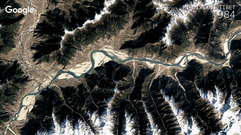 |
| 40 years of Landsat data for river monitoring |
I looked for Irish examples but even changes in Dublin through the Celtic tiger era are a bit hard to make out, partly because we get so many cloudy days and there is therefore less data for a smooth animation. Line banding on the Landsat 5 sensors in Dublin bay also makes it look a bit messy. The construction of the islands in Dubai is well worth a look to get you started.

Nice find! It is a pity about the unsurprising constant cloud cover over Ireland though. I remember reading before about a technique Mapbox have been working on to create a 'Cloudless Atlas' from LandSat imagery (https://www.wired.com/2013/05/a-cloudless-atlas). Looked really impressive but unfortunately I don't think they are retroactively applying it to historical imagery.
ReplyDeleteThat is really interesting - our Marobs pltform will find the nearest cloud free day and get you the tile for there, but changes in land cover (especially during a growing season) will be quite drastic in just a few weeks. There's seems to take average of all cloud free pixeland seem quite confident they can track changes in vegetation - one to watch definitely, thanks for sharing!
DeleteThis is really interesting, I wasn't aware that satellite imagery was available from this long ago.
ReplyDeleteThat's incredible, if used properly it could help show the effectsame of climate change.....present and future
ReplyDelete