Thursday, 11 April 2019

EUGEO and CIG2019

We had such a good response this year that we have had to organise a dual EO session for the joint CIG/EUGEO this year in Galway. Sessions 2.3.7 and 2.4.7 - should be a great selection of talks. Thanks to all who applied and to co-convenor Daithí for all the hard work in compiling the submissions.

Conference programme available at this link


Tuesday, 2 April 2019

BIM From a Distance

Part 1 of our article on 'BIM from a Distance' has just been published in the Surveyors Journal. This was a SCSI/ESA funded study using high resolution passive and active satellites to monitor construction in Dublin port. Part 1 introduces the problem, proposed methodology etc - Part 2 will cover the results.


This was a very interesting study to be part of - basically proving to me that high resolution satellites can measure the dimensions of structures achieving relative accuracies of +/- 0.5m. This means that the process is not entirely dissimilar from traditional methods band even more importantly is repeatable and exportable for any site worldwide. We presented these results in CIG2018 in Maynooth and again in Survey Ireland 2018 in Dunboyne.

Monday, 25 March 2019

Plane Spotters V Drone Renegades

I deleted a few awful drone puns as potential headers for this post - will be hard to get through the rest of it without making one but I am determined to do it. 

There was an interesting initiative announced in the Journal.ie  at the weekend. Warning posters have been placed all around the boundary of Dublin Airport with information on how airplane enthusiasts/spotters can report suspicious drone usage. It might be stereotyping to characterise them as such, but considering airplane spotters are probably fans of rules, regulations and order; are operating in the problem zone; have binoculars and are taking pictures constantly - they are good allies to have in the fight against drone renegades like those who closed down Gatwick (and Dublin to a lesser extent) a few months back.


Pic courtesy of thejournal.ie
 The main complaints in the comments section were about why the notices are 'as gaeilge'. My word of the day is Ladrainn - which means drone, apparently.

Monday, 11 March 2019

USGS considering move towards charging for Landsat imagery again

I read about this recently but it popped up again on my twitter feed this morning - the USGS (of Landsat fame) are considering reinstating charges for Landsat imagery. For those of you more familiar with the Copernicus (ESA) era of earth observation satellites, NASA/USGS were the founders of the free earth observation data model. Three or four years after I finished undergrad they made all the data from Landsat 5 and 7 available to users - free of charge. Suddenly this treasure-trove of free, 30m pixel size multispectral data (updated every 12 days or so) appeared and the number of users (myself included) skyrocketed. See the graph below showing number of publications using Landsat imagery after the 2008 switch in policy - that's almost exponential growth, if you are looking for an indicator to show a policy works then that what more could you ask.


So, "More users?" I hear you say, "So what - USGS/NASA/USA are losing out financially right?" Right in a way - but very wrong in another - all of the users are people using Landsat data to improve crop health, increase forestry yields, manage the ocean and coastal resources, mitigate natural disasters or private sector looking to sell services, develop apps, start companies - this all returns massive rewards to the national accounts, not just one publicly funded body. They definitely aren't all in the US - but a paper that is written by authors in India for example and publishes a useful case study - can that not help a US company?

Spatial data provides massive value to any economy - just look at the value that was placed on geospatial data in Ireland a few years back by an ESRI/OSi study. Even as a small nation the direct value was measured at around €120m and additional benefits through time savings etc of around €279million.

So I don't know where this decision is coming from - although I can guess...and considering the fact Copernicus is here now with more, better satellites - what are they hoping to happen? Is Landsat 9 going to be that much of a game changer? Off the top of my head the only things Landsat 8 has that the Sentinels don't is a high resolution coastal blue band and a high resolution thermal. So they will charge for the data, when it is in less demand?


Tuesday, 5 March 2019

The New Normal

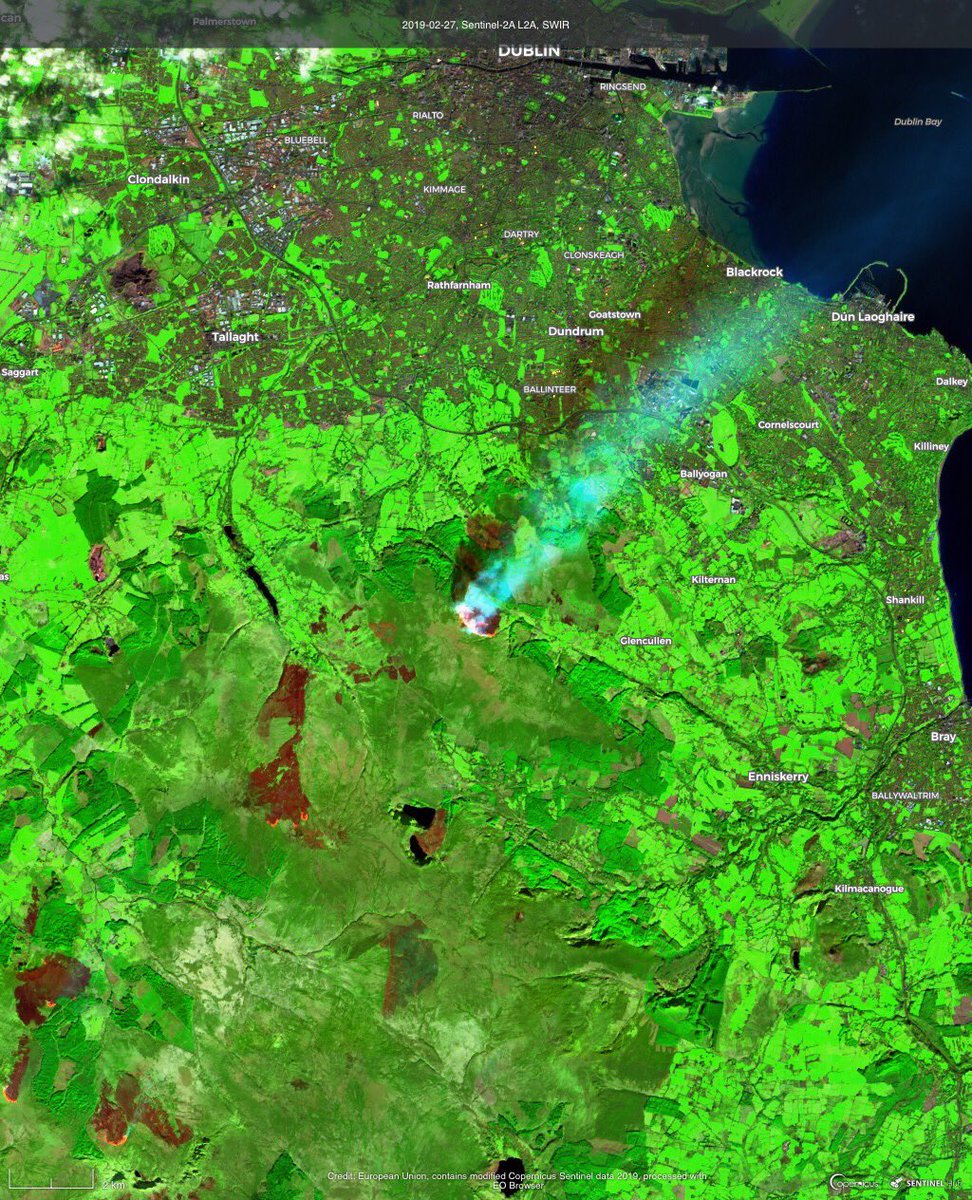
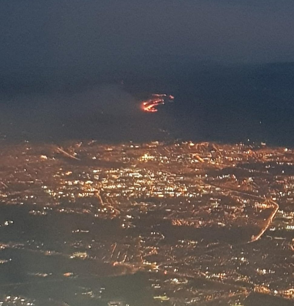
Copernicus are doing a series of posts on Twitter entitled 'the new normal?'. Images of wildfires in the middle of winter - often only a few kilometres from snow. These images were on the Dublin Fire Brigade twitter page at the weekend of the fires in the Dublin mountains. One day later the whole county was covered in snow. The whole country is still way behind on groundwater levels, see Teagasc's latest map of the month for satellite derived measurements of soil moisture. Measured via MODIS at 1km spatial resolution, you can see how bad 2018 was for crops.

SWIR Image from Sentinel 2 - Copernicus Imagery

Image taken out window of plane leaving Dublin Airport - Dublin Fire Brigade Twitter

 It is the same all over Europe at present - Croatia, Romania, Spain, Bosnia-Herzegovina - have a look at the Copernicus Twitter Page

Tuesday, 26 February 2019

#Technologyweek on Twitter

Make sure to take a look at some of the twitter posts in the sidebar - I'm giving a few updates for #Technologyweek for #YearofGeography.

Friday, 22 February 2019

Story Telling From Space

I came across an excellent intro on satellite imagery on twitter during the week -  but what really caught my attention was some of the supports dedicated to journalists, like 'Satellite Journalism - the big picture' - a paper showcasing loads of examples of EU data used in investigations around the world, this has so many examples from a quick skim I gave it this morning that it is a must read.


Image from 'Satellite Journalism - the Big picture'


Another interesting resource - Earth Rise Media is an EO company that aims to help journalists with 'story telling from space'. tons of good stuff in these different links - need time to go through it properly and I want to have a proper read of the satellite journalism one.


About Me

My photo
My name is Conor. I am a Lecturer at the Department of Geography at Maynooth University. These few lines will (hopefully) chart my progress through academia and the world of research.