Friday, 15 February 2019

Free (LiDAR) Datsets

I came across a great resource recently and have directed the MSc GIS/RS students to it for their next assignment. OpenTopography is a huge repository of freely available topographic data (raster and vector) but of particular interest to the GIS/RS students is the point cloud data that they are using for their LiDAR assignment. 

I counted 271 aerial LiDAR datasets, 8 terrestrial laser scanner datasets and 4 photogrammetrically-derived point clouds. I was impressed not only by the volume but also the variety, with point clouds of everything ranging from volcanoes to landslides to urban centres. It is a simple drag and drop selection and download interface and you don't even need to register for the smaller files. It will also provide partial processing for you in the download options! Data is largely concentrated in USA but I spotted data for New Zealand, Spain and other locations.


My only complaint so far is that when you are selecting data for one of the change detection studies (very helpfully flagged as such in the listing) you do not know where in the test site the change occurred - but the dataset is too large to download it all and find out, so you are kind of snookered! Note: I googled for a nice image to show snookered but there was none, what's up with that?




Friday, 8 February 2019

GIS in Schools

Some big news for geography (and geo in general) just before Christmas. ESRI - the largest supplier of GIS software in the world (and founded by the man with the excellent name - Jack Dangermond) has recently announced nearly half a billion euro worth of GIS and mapping software for primary and secondary schools around the country. Almost a million students, in 4,000 schools will all have free access to AGOL. This all feeds into the digital strategy action plan - launched in June by Minister Bruton and will be a huge benefit to students. There was one map on the wall of the geography class in my school - that was it.


Its a shame with this type of investment going into the schools that Geography is not still a compulsory subject at junior level.

Congrats to all involved in the initiative - I have heard a few familiar names come up in conversation.

Thursday, 17 January 2019

Worldview 4- Gyroscope Failure

Looks like it may be curtains for the satellite providing the highest image resolution currently available on the market. At 0.31m (max spatial resolution permissible for commercial sale under US law - no idea what it was technically capable of) World view 4's panchromatic band was the crispest image you could get from space to the best of my knowledge. I have never used any WV4 data - but having used the Pleiades 0.5m panchromatic images - you could see road markings, cars, the whole area in incredible detail so can only imagine how good it was almost x2 better. 


Space.com and others reported WV4 has experience a gyroscope malfunction - which will stop it from pointing properly. These VHR (very high resolution) satellites were critically dependant on pointing capabilities, as with the longer FOV required to enable a hi-res image capture, the image footprint was reduced correspondingly. Targets of opportunity and localized areas in high detail were their specialty.

Interesting figures given on return of investment for WV4 - net book value is €155 million (i assume that means to build and launch - possibly maintain and process data), but the returns were approximately €85m in 2018 alone. Having launched in Nov 2016 - had it paid for itself yet? Possibly.

Digital Globe plan to continue efforts to restore it - but they expect those efforts to be unsuccessful.


Monday, 14 January 2019

2018 - A year in review

A bit late doing this update - but another interesting one in 2018..

  • One blizzard
  • One heat wave
  • One drought
  • One MSc accredited
  • One paper
  • 2 jobs
  • 10 modules
  • 3 conferences

Roll on 2019!

Friday, 14 December 2018

S2 Imagery - Atmospherically Corrected

Big news on the Copernicus twitter feed today - all of the Sentinel 2 imagery is now available to download, atmospherically corrected to Level 2A. This is available worldwide and will be a fantastic resource cutting out alot of the early processing steps.

Interesting though - as I look at some of the examples like in this post - the 3D definition in the crevasses etc are removed following atmospheric correction. It even seems to be removing shadows - I know some forms of atmospheric correction reduce topographic effects - but not to that extent. It does make image interpretation a bit harder but I suppose it does have the intended effect of making each pixel measurable - from a satellite image - as though you were standing on the ground with a handheld spectrometer.


Thursday, 13 December 2018

Making Victorian Dublin

Thanks to Dr. Avril Behan from DIT for tipping me off on this - arguably (actually no argument) the fanciest building to house any Geography Dept in the country (and Rhetoric here in Maynooth is a beauty) - a recent project by DIT grad Dr. Conor Dore is now available online. The Museum Building is now completely modelled in 3D with an interactive online point cloud available for viewing.

Link to the full story here at the MakingVictorianDublin website.

I was there not too long ago for a meeting in the (whatever is the fancy Victorian word for the) lobby (foyer?) - and remember the beautiful stairwell and domed ceiling - but I don't remember the big fossils in this pic.


Friday, 7 December 2018

IEOS2018 - Big Success

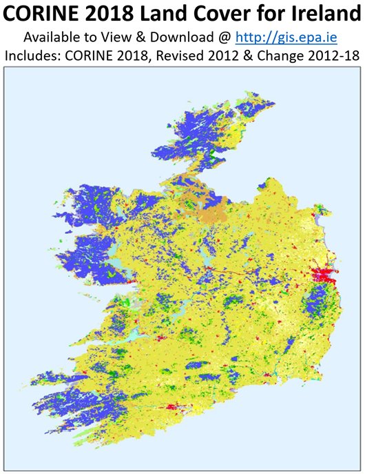
Congrats to the Stuart, Jesko and the other organisers yesterday from Teagasc - beginning with the announcement that Team Teagasc won the Farming by Satellite competition hosted by ESA during the week, followed by a great keynote by Dr. Daniel McInerney from Coillte on Open Source processing methods for forestry, and then a full day of great sessions - it was a really useful day of talks. We presented on our work with OSi on the Change Detection project, and OSi and EPA followed with a joint presentation on their work on Land Cover/Habitat Mapping. Kevin Lydon from EPA also announced the release of the new Corine 2018 dataset.


There was a great turn-out from the Maynooth MSc GIS/RS students - which I hope they really found useful. The difference in seeing people who work on a single theme every day (like marine, or Ag) present their problems and solutions really helps to show how important some of the things i keep banging on about are - like automation, data fusion, data calibration, accuracy assessments. It was lucky that it was so close to Maynooth this year - if had been hosted in UCC or NUIG for example they wouldn't have had that chance to just hop on the train.

My surname ended up as Calahane on the name badge, as usual.

Today is Day 2 - with the python coding workshop.

About Me

My photo
My name is Conor. I am a Lecturer at the Department of Geography at Maynooth University. These few lines will (hopefully) chart my progress through academia and the world of research.